
72 Farnham sites have been put forward for housing, with room for 3,772 homes. Here is every site, its council rating and when you can comment on the plan.
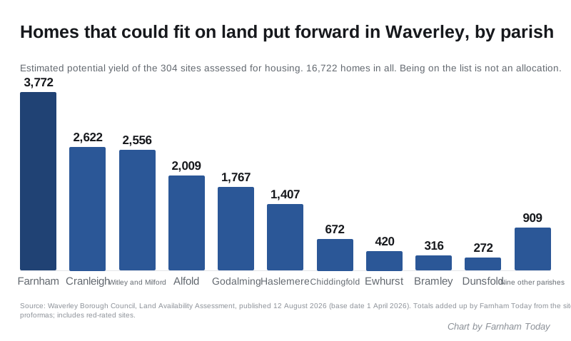
Landowners and developers have put forward 72 sites in and around Farnham for housing. Waverley Borough Council estimates they could hold 3,772 homes between them. That is more than any other parish in the borough.
The figures come from the council’s Land Availability Assessment, a 400-page study published on 12 August. It is the council’s first full list of the land that could be used to meet Waverley’s much higher housing target.
The council gives a potential number of homes for each site but no totals. We added up all 304 residential site assessments. The borough-wide figure is 16,722 homes.
Being on the list does not mean a site will be built on. The council says so on every page. The assessment does not allocate land, grant planning permission or decide anything. It is the list the new Local Plan will choose from.
What the list says about Farnham
The assessment treats Farnham as the whole town council area: the town centre, Hale, Upper Hale, Weybourne, Badshot Lea, Wrecclesham, the Bourne and Runfold.
Each site gets a colour. The council says the colour reflects “the current level of planning constraint”, not whether it will be developed.
- Green, 29 sites, 2,043 homes. No known constraint would stop development at this stage.
- Amber, 28 sites, 1,246 homes. There is a constraint, such as landscape, ancient woodland or flood risk, that needs more work before the site could be called suitable.
- Red, 15 sites, 483 homes. Rejected for now. Every Farnham red site comes with a written reason for rejection.
Take out the red sites and the council’s own delivery estimates put 1,720 homes in the first five years, 1,369 in years six to ten and 200 in years 11 to 15.
Not everything on the list is new. Seven Farnham sites, with 478 homes between them, are already allocated for housing:
- The Woolmead, 138 homes, allocated in Local Plan Part 1
- Centrum Business Park, East Street, 150 homes, allocated in the Farnham Neighbourhood Plan
- SSE Depot, Badshot Lea, 100 homes, Neighbourhood Plan
- Cobgates, 40 homes, Neighbourhood Plan
- Surrey Sawmill, 20 homes, Neighbourhood Plan
- Kimbers Lane, 20 homes, Neighbourhood Plan, now rated red
- Colemans Yard, Wrecclesham, 10 homes, Neighbourhood Plan
The rest came from the council’s Call for Sites in 2024 and 2025 (37 sites), earlier land assessments (20), the rolling call for sites (5) and refused planning applications (3).
The biggest Farnham sites
Five Farnham sites are estimated at 150 homes or more.
- Potts Farm, Runwick Lane (FA047), 300 homes, amber. 18.21 hectares of farmland on the western edge of town, promoted for homes, self-build, leisure and a SANG (a new public green space). It is all inside an Area of Great Landscape Value, so the council says the landscape impact needs assessing first.
- Romans Business and Industrial Park (FA011), 250 homes, green. An existing employment site inside the settlement boundary. The council would need “justification for the loss of the existing employment use”.
- Land South of Badshot Lea, Parcel A (FA177), 250 homes, green. 8.01 hectares of pasture. Five per cent of it is a recorded archaeological site, the Neolithic long barrow near Badshot Lea.
- Land West of St Georges Road (FA338), 250 homes, green. 11.36 hectares of nursery and pasture south of Badshot Lea, promoted with a community building. A third of it is an archaeological site.
- Centrum Business Park, 35-42 East Street (FA084), 150 homes, green. Already allocated in the Neighbourhood Plan. Part is in Flood Zone 2.
Badshot Lea features heavily. Of the 29 green Farnham sites, ten name Badshot Lea, Green Lane, St Georges Road or Badshot Farm Lane in their title.
One Hale Road site is rejected
Land at Hale Road (FA157), 5.73 hectares next to Farnham Park, is rated red. The council’s reason is that the land “has consent for use as Suitable Alternative Natural Greenspace”. Two more Hale sites are red: Folly Hill, Upper Hale (FA148) and Stockwood Way, Hale (FA150), at 60 homes each.
Not all of it is for housing
Farnham has 97 entries in the assessment. The other 25 were put forward for something other than homes. They include:
- a secondary school on land off Weydon Lane (FA059)
- new sports pitches off Green Lane, Lower Weybourne Lane and Weydon Lane
- Tices Meadow, Badshot Lea, promoted for SANG, nature gain and flood resilience (FA053)
- a Gypsy and Traveller site at Legend Acres, River Lane (FA229)
- three walking and cycling routes, including one parallel to Station Hill
How this compares with the target
The government’s housing figure for Waverley is 1,458 homes a year, up from 710 under the current plan. We covered what that means in our Farnham planning explainer.
The new plan will run from 2026 to 2044. Eighteen years at 1,458 a year comes to 26,244 homes. That is our arithmetic, not a council figure. Homes already built or approved count towards any final target, and the council can test whether the figure is deliverable as the plan goes on.
Even so, the whole list adds up to 16,722 homes, including the red sites. The council says it “does not believe that it can accommodate” the government’s number.
What it means for you
- You cannot comment on the assessment itself. The council says it is “not a document that is consulted on”.
- Your chance comes with the Local Plan. The council’s timetable sets out the dates below.
- Check the map. The council’s interactive map shows every site and its colour. Each site’s full assessment is in the site proformas PDF (20MB). Use the site index to find the page.
- A green rating is not a decision. The council’s FAQ says a green site “has not been approved as a site suitable for allocation”, and a red site “is not automatically excluded”.
| Stage | Date |
|---|---|
| Gateway 1 (government check-in) | 23 October 2026 |
| Consultation on plan contents and evidence | 8 February to 22 March 2027 |
| Gateway 2 | 18 October 2027 |
| Consultation on the proposed Local Plan | 6 March to 1 May 2028 |
| Submitted for examination | 14 August 2028 |
| Adoption | 31 January 2029 |
Every Farnham site in the assessment
The table lists all 72 Farnham sites assessed for housing. “Homes” is the council’s estimated potential yield. For one red site, 10 Acre Walk in Rowledge, put forward as an extra care home, the council gives no number of homes.
| Ref | Site | Rating | Homes |
|---|---|---|---|
| FA011 | Romans Business and Industrial Park, Farnham | Green | 250 |
| FA177 | Land South of Badshot Lea (Parcel A) | Green | 250 |
| FA338 | Land West of St Georges Road | Green | 250 |
| FA084 | Centrum Business Park, 35-42 East Street | Green | 150 |
| FA033 | Land at Lower Weybourne Lane, Farnham | Green | 140 |
| FA077 | The Woolmead, Farnham | Green | 138 |
| FA018 | Land South of The Depot and East of Green Lane, Badshot Lea | Green | 100 |
| FA079 | SSE Depot, Badshot Lea | Green | 100 |
| FA045 | Land at Watership Farm/Cottage, Watership Cottage, Badshot Farm Lane, Farnham | Green | 90 |
| FA057 | Land to The West of Folly Heights, Folly Hill, Farnham | Green | 80 |
| FA019 | Land West of Green Lane, Badshot Lea, Farnham | Green | 50 |
| FA023 | Land East of Three Stiles Road, Farnham | Green | 50 |
| FA024 | Southern Site, Century Farm, Green Lane, Farnham | Green | 42 |
| FA013 | Monkton Farm, Monkton Lane | Green | 41 |
| FA083 | Cobgates | Green | 40 |
| FA162 | Hill Fields, Gardeners Hill Road | Green | 40 |
| FA039 | Land Off Green Lane, Farnham | Green | 38 |
| FA028 | Land East of Tongham Road, Runfold | Green | 26 |
| FA086 | Surrey Sawmill | Green | 20 |
| FA144 | Land at Tongham Road, Runfold | Green | 20 |
| FA176 | Orchard Cottage, Crown Lane, Farnham | Green | 20 |
| FA363 | Land to the West of Old Park Lane, Farnham | Green | 20 |
| FA248 | Upper Old Park Lane | Green | 17 |
| FA042 | Land Surrounding 35 Frensham Vale, Lower Bourne | Green | 15 |
| FA172 | Land West of Crown Lane, Badshot Lea | Green | 15 |
| FA342 | 1 Crown Drive, Farnham | Green | 11 |
| FA081 | Colemans Yard, School Hill, Wrecclesham | Green | 10 |
| FA184 | Hook Cottage, Guildford Road, Runfold | Green | 10 |
| FA343 | 3 Badshot Lea Road | Green | 10 |
| FA047 | Potts Farm, Runwick Lane, Farnham | Amber | 300 |
| FA167 | Land at Frensham Vale Park, Rowledge, Farnham | Amber | 120 |
| FA173 | Land at Manley Bridge Farm, Manley Bridge Road, Rowledge | Amber | 100 |
| FA066-1 | North of Guildford Road, Farnham (SUEZ UK Environment Ltd) | Amber | 80 |
| FA340 | Land South of Wrecclesham Hill | Amber | 80 |
| FA164 | Land to The South of Monkton Lane | Amber | 56 |
| FA170 | Land South of Frensham Vale Road | Amber | 50 |
| FA066-2 | Off Rock House Lane, Farnham (SUEZ UK Environment Ltd) | Amber | 40 |
| FA026 | West Site, Century Farm, Green Lane, Farnham | Amber | 36 |
| FA182 | 24 Moor Park Lane | Amber | 32 |
| FA009 | Land North of Wrecclesham Hill, Farnham | Amber | 30 |
| FA043 | Crooksbury View, Low Lane, Badshot Lea | Amber | 30 |
| FA054 | Land to The East of Badshot Lea | Amber | 30 |
| FA056 | Pound House, 27 Wrecclesham Hill, Wrecclesham, Farnham | Amber | 30 |
| FA161 | Land at Cedar House, Byworth Close | Amber | 30 |
| FA362 | Land at Runwick House | Amber | 30 |
| FA040 | Land North of Six Bells Ph, Hale Road, Farnham | Amber | 25 |
| FA058 | Bells Piece, Hale Road | Amber | 20 |
| FA067 | Land West of Lavender Lane, Rowledge | Amber | 20 |
| FA025 | Fairvalley Farm, 6a Rosemary Lane, Rowledge, Farnham | Amber | 15 |
| FA153 | Land at Runwick Lane, Dippenhall | Amber | 15 |
| FA200 | Abbey Business Park, Monks Walk | Amber | 13 |
| FA007 | North Site, Holt Pound Farm, Wrecclesham Hill, Farnham | Amber | 12 |
| FA339 | 25 Wrecclesham Hill | Amber | 12 |
| FA021 | Land at Cherryfields, Fullers Road, Rowledge | Amber | 10 |
| FA065 | Land to The East of Tilford Road and South of Burrows Dene | Amber | 10 |
| FA163 | Wrecclesham Farm Nursery, Echo Barn Lane, Farnham | Amber | 10 |
| FA341 | Ravenswood Farm Cottage Lower Hale | Amber | 10 |
| FA157 | Land at Hale Road | Red (rejected) | 120 |
| FA148 | Land at Folly Hill, Upper Hale | Red (rejected) | 60 |
| FA150 | Land at Stockwood Way, Hale (Parcel B) | Red (rejected) | 60 |
| FA147 | Preymead Farm, Badshot Lea | Red (rejected) | 35 |
| FA151 | Land at Preymead Farm Industrial Estate, Badshot Lea Road | Red (rejected) | 31 |
| FA005 | A325 Dogflud Way Between Lidl and Eastgate House Farnham, 28 East Street | Red (rejected) | 30 |
| FA006 | Land at Burnt Hill Road, The Bourne | Red (rejected) | 25 |
| FA149 | Land at Clumps End, Clumps Road | Red (rejected) | 25 |
| FA185 | 24 Sussex House, Great Austins | Red (rejected) | 25 |
| FA085 | Kimbers Lane, Farnham | Red (rejected) | 20 |
| FA158 | Land at Redhill House, Tilford Road | Red (rejected) | 20 |
| FA159 | 123a Badshot Lea Road, Badshot Lea | Red (rejected) | 12 |
| FA239 | Land at Waverley's Folly, St Georges Road, Badshot Lea | Red (rejected) | 10 |
| FA337 | Land at The Diary Studios, Runfold St George | Red (rejected) | 10 |
| FA178 | 10 Acre Walk, Clifton Close, Rowledge | Red (rejected) | not given |
Sources
- Waverley Borough Council, Land Availability Assessment 2026, published 12 August 2026, base date 1 April 2026: the Appendix 1 site proformas for every site, rating, estimated yield, delivery period, site source, designation and reason for rejection quoted here, and the site assessment index for the count of 357 proformas. All totals are Farnham Today’s sums of the individual proformas; the council does not publish them. Read 25 September 2026.
- Waverley Borough Council, LAA frequently asked questions for what the ratings mean and why the assessment is not consulted on.
- Waverley Borough Council, Local Plan timetable, agreed 2 June 2026, for every date in the timetable table.
- Waverley Borough Council, Call for Sites news release, 12 September 2025, for the 1,458 and 710 figures and the council’s view of the target.
Have your say